Monday, April 25, 2022

Driving Montana to Alberta

Day 3 of our travels home begin with a lot of dark clouds and tiny glimpses of blue sky above and doesn’t get much better.  We do have some sunshine to enjoy at times but the weather definitely convinces us we are heading north.

Cattle range

We are passing fields and fields of cattle, these ones must have been fed not long ago the way they gather around a long row of hay.  There are so many newborns in these herds, and the babies seem to enjoy laying in the hay, as I’d noticed in the ones closer to the highway.  I was so engrossed, though, that I didn’t get pictures and I saw that so many times!

Closer to snowfall now

The traffic is very light this morning, as most days have been in less populated areas.  We are seeing serious snowfall ahead, and can only hope that it stays to the west of us and isn’t on any of the road ahead.  We are approaching Butte and the temperature is 4c (30f) at this time of our drive.

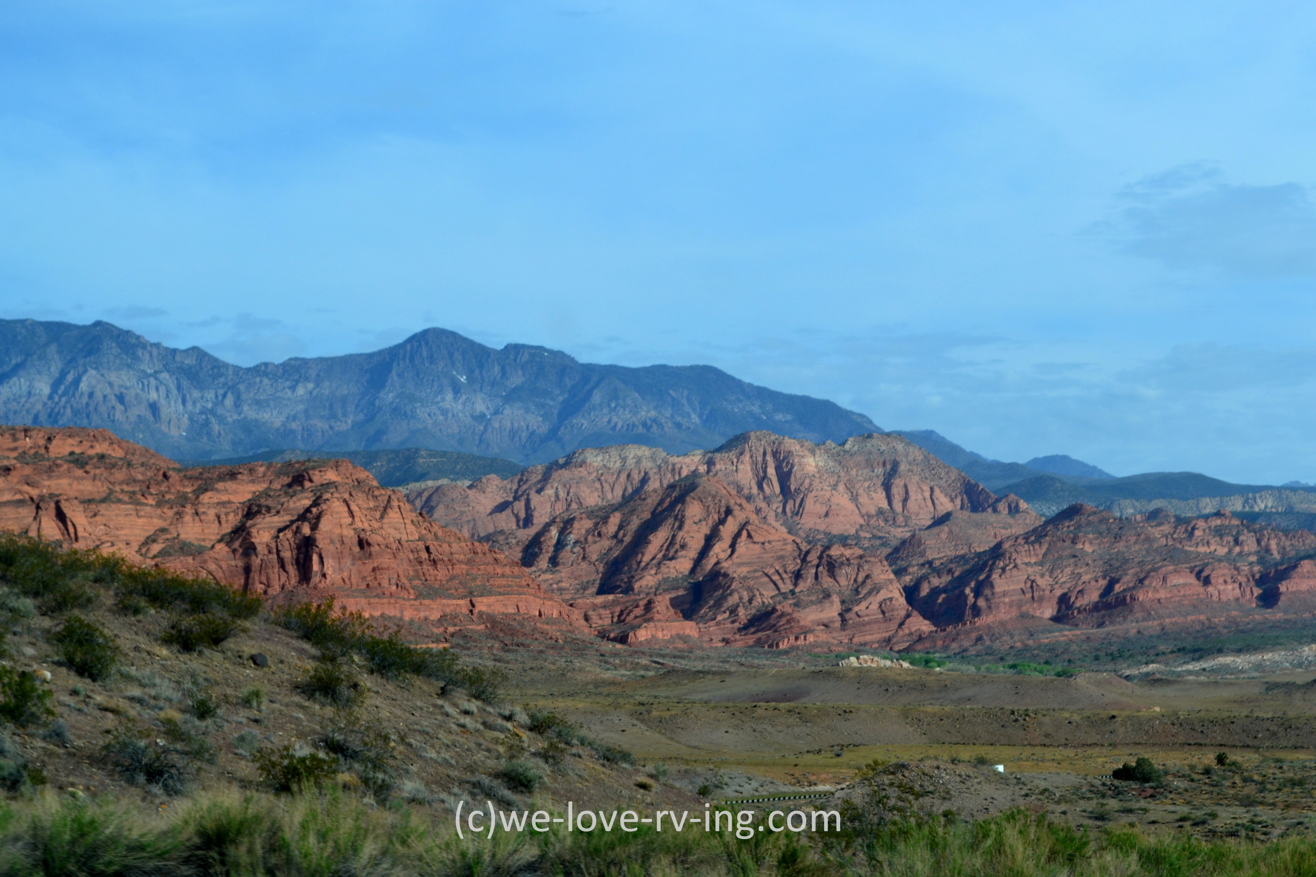
Winding highway through the rocks

This reminded me of the Virgin River Gorge but I couldn’t find any name for it.  The highway winds around the rock faces and offers some great rustic rock as we climb up.  Although they’re not showing in this photo, the Big Belt Mountains are on the east side of the Missouri River, off in the distance from here, so I don’t believe these are part of that.  We are going to see more snow covered mountains ahead.

Little Prickly Pear Creek

We crossed over the Little Prickly Pear Creek on this stretch of road, which is a tributary of the Missouri River.  Prickly Pear is a cactus plant known to be in the desert so it doesn’t sound quite right looking at this landscape, but some of this area in Montana is actually desert, so I’m guessing there are some prickly pear plants behind these rocky mountains.
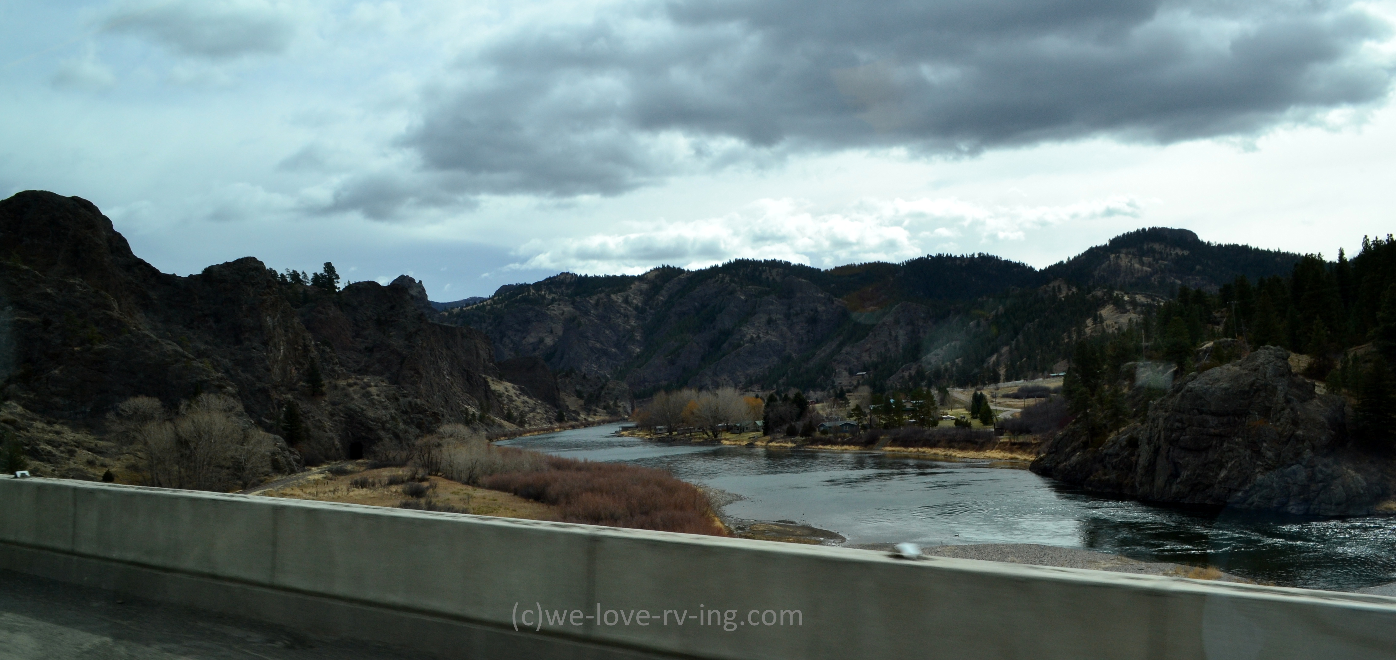
Missouri River

This is the Lewis and Clark County so it shouldn’t be surprising that we’d see the Missouri River, which we are crossing over here.  Their expedition was a total of 7900 km (4700 mi) in 1804-1806 taking them across the country on the Missouri and then the Columbia River.  Great Falls, a town we pass on Hwy 15 has a Lewis & Clark Interpretive Centre which would share much of that history.  

Montana Plains

As we pass through northern Montana, we see a lot of fields, which really offer no great views other than when we find the heart of the crops of those fields.  And we did see plenty of them including this oil digger, which is called a pumpjack that we see here.  We saw several today, which are like so many we’ve seen in different parts of the country but I never knew what they were called.

Field of Vintage travels

Signs of times gone by, we see a display of some very old trucks that were likely for farm use back in their time as well as an old car that would have been considered a luxury then.  Wouldn’t it be interesting to really know the stories behind them all?

Welcome!

We arrived at the border at the time that we’d given as our time of arrival on our newly acquired ArriveCan online form but as it turns out, there is quite a line up in front of us, so much for planned timing.  It did take over 90 minutes to pass through the border with the long lineup but that was shorter than the 4 hour wait we learned about happening the days before.  Once through, we are back in Canada. 

Southern Alberta plains

The scenery is so much like northern Montana while we drive through southern Alberta as we follow the Crowsnest Highway.  The sights are much the same as we see early days of crop fields between the small towns and villages before we reach Lethbridge, AB. 
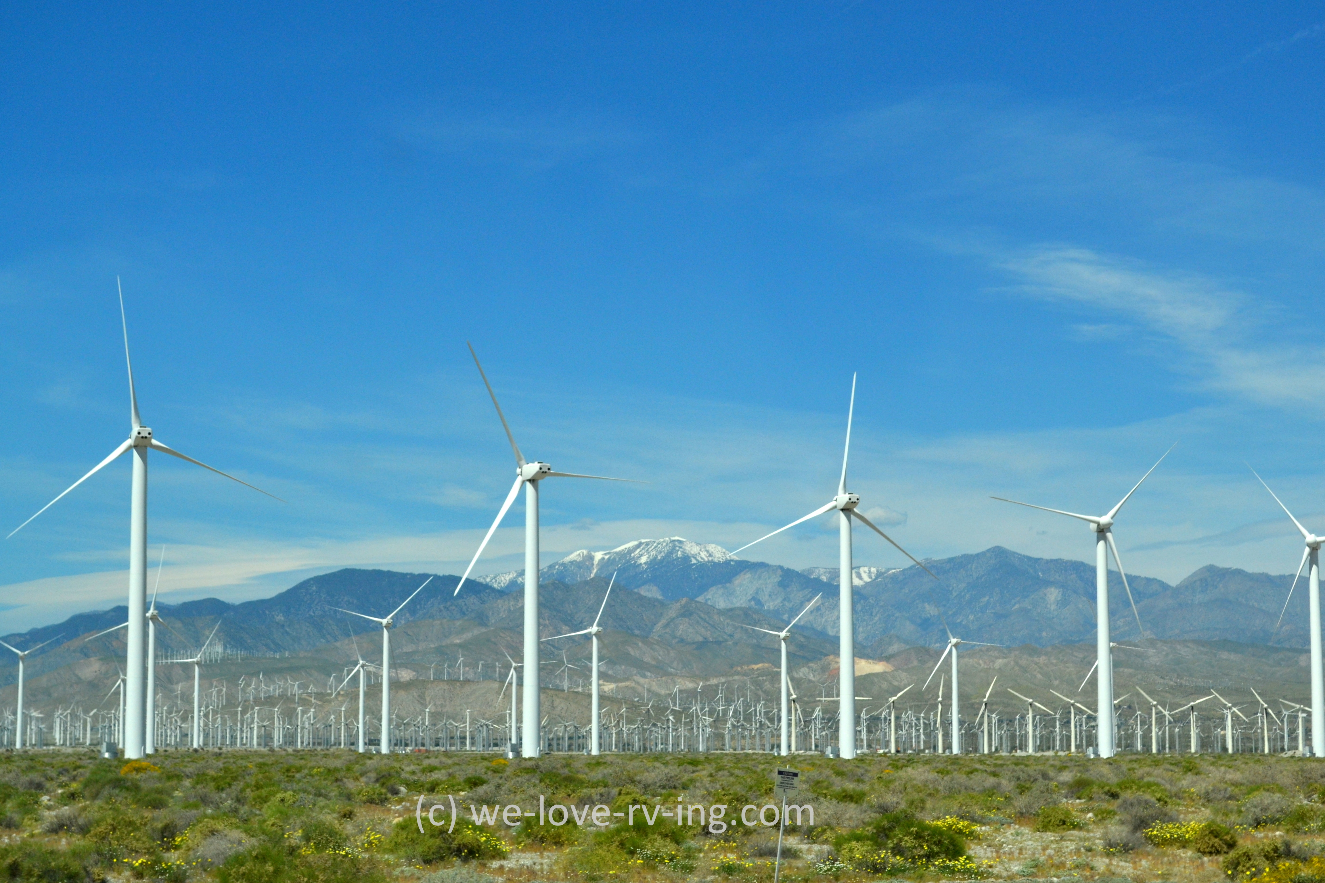
Windmills in Alberta 

We may now know where the gigantic windmill blades were heading, (shown here).  The size is so deceiving but these are off in the distance and I do believe they’re of the same size.  This last photo of the day reminds me of the first photo on our day of departure from Palm Springs, CA.  This has fewer windmills and no blue sky and sunshine but still a reminder. 

We are not far from Medicine Hat, AB, our destination for the next couple of days where we will visit with some very dear family friends.  Sounds like a good plan, eh?


Wednesday, April 20, 2022

Road Trip ~ Utah ~ Idaho

Our second day began after a very enjoyable overnight stay at My Place Hotel in St. George. Accommodations were great and the service was, too.  We’d not heard of this chain before and something I don’t normally do here but I would recommend My Place to everyone.  They have tiny kitchens in the rooms plus they accept dogs!  Definitely a bonus on travels.

Red rock in Utah

The sunny day offers some great sights of red rock as we make our way north on Hwy 15.   The highway has many long straight stretches of road and we often see signs that say “Drowsy drivers use next exit”.  There were some hills to climb and I was so busy watching the views, I almost missed the sign that said ‘Dog Valley Summit 6180 FT’ and snow only seen on the distant mountains.

Purple fields

Utah is known to grow lavender but I don’t think this would qualify for that.  It was a pretty change from the roadside fields we’d been seeing so I thought it was worth taking a photo of.  We’d passed so many fields of Black Angus cattle with lots of little ones, that I stopped counting or taking photos of them.

Snow in Utah

We are beginning to see more snow on the mountains as we drive through Utah.  They offer fantastic backdrops to any photo and I can never seem to take enough of them.  The temperatures on our travels were definitely changing from what we’d left behind.

Churches of Salt Lake City

As we approach Salt Lake City, we see this church in the distance.  This would be only one of many beautiful churches in this city.  I wasn’t able to determine which church this one is but in researching for that information, I did see many architectural designs that are so interesting in Salt Lake City.

Salt Lake City

Salt Lake City and area have a population of over 1.1 million so is a very busy place.  The freeway that passes through is Hwy 15, the one we’ve been following and we’d been told by others who travel this way that it can be so busy and slow.  We timed it so well, purely by chance, passing through on midday Sunday and the traffic was fairly light with nothing slowing us down. 

Basalt columns

Within a couple of hours we’d passed many fields of cattle in Utah before crossing into Idaho and seeing these basalt columns, a very small and younger version of the Giant’s Causeway we saw in Ireland.  They’re created by the cooling and contracting of lava so we know these have been there for a very long time.

Silos in Utah

We are now getting into the flatlands where we’ll see many of these silos.  These containers for grain definitely indicate the big business that these fields create.  We pass so many different ones during our drive through northern Utah. 

Dubois, Utah

We made a quick stop at Dubois to see if we could find some fuel, but what we did find was basically a ghost town.  There was a gas station that was open but being Sunday, if there are any other operating businesses in Dubois, they weren’t open.  It is only about a 320 km (200 mi) drive crossing through southeastern Idaho from Utah to Montana so we waited for the next stop for fuel.  We are now heading into our fifth state on this trip.

Turbine blades

These are wind turbine blades that were travelling north following the same route we were so we saw them twice, but had to say ‘wow’ every time we saw them.  Never did we realize the size of them, in spite of seeing so many once they’re installed and working.  These are HUGE!

We spent the night in Dillon, Montana and although we didn’t have time to see much, we enjoyed what we did see.  It has a population of less than 4,000 but it took only one, the desk clerk at the hotel, to give us a very nice welcome. 


Tuesday, April 12, 2022

Palm Springs, CA ~ Virgin River Gorge

The journey home begins on a sunny morning in Palm Springs, CA.  We’ve planned a route that will take us into different scenery and views than we’ve seen before.  It is always exciting to see new parts of the country and I will have the camera ready to capture as much as I can.


Wind Turbines

These are very symbolic for the Coachella Valley where Palm Springs sits, we won’t likely be seeing too many of these on our travels north.  There are thousands of windmills or wind turbines in the area which also tells you there are plenty of windy days, too. 


Mojave Desert sights

We head north up through the Yucca Valley which is bordered by Joshua Tree Park and is part of the Mojave Desert and is 3,000’ elevation.  The name comes from the Yucca palm tree, usually called the Joshua tree which are seen in this area.  It is native to the southwestern US.  We’ll see plenty of nothing once we get up there other than the occasional settlement and some interesting sights along the way.  


Barstow to Yermo, California

We then follow Hwy 247 for a quiet drive up to Barstow, CA.  As we drive into the city, we are seeing banners on all the city lamps honoring veterans with their different names on each one.  Very nice tribute to them all.  As we connect to Hwy 15 and head northeast we are seeing different sights that are tributes to the veterans.  The ‘64” photo is of the Liberty Sculpture Park at Yermo, CA as a tribute to “the fight for freedom”.  Eddie World ice cream structure is the largest gas station in California!  


Ivanpah Solar Plant

We’re approaching the border crossing into Nevada and come upon this huge solar panel plant.  In doing some searching, I’ve learned it is called the Ivanpah Solar Plant and is the world’s largest one!  The towers are almost mesmerising as we drive by, they are so bright.  The Ivanpah system covers 3500 acres of public land in the Mojave in total.


Primm, Nevada

We soon cross into Nevada and sitting on both sides of the highway is a small version of Vegas with three casinos, one of which is closed now, plus some outlet stores.  We are past it within a minute on the road, Primm is very small community.  


Las Vegas, Nevada

In less than an hour we are passing through the busy city of Las Vegas.  We are staying on Hwy 15 and the freeway bypasses the busiest parts of the city, but is certainly busy enough.  Most would know what Vegas looks like without me sharing photos of it but something new has been added within the past few years and that is this big beautiful stadium!  Great that it sits along the freeway so we were able to see it. 


Mesquite, Nevada

Mesquite sits close to the border into Utah so we’re beginning to see the red rock that Utah is so famous for.  Mesquite is named after a timber found in the area. Hwy 15 covers 199 km (123 mi) in Nevada so we spent very little time in that state. This overpass is an example of how so many are decorated rather than just being concrete.  I’ve taken so many photos of others that I could probably write a book on them, but I won’t. (:


Virgin River Gorge

It wouldn’t be easy to explain my excitement when we arrived at the Virgin River Gorge!  We’d been here before but it had been several years and it was like seeing it for the first time again.  Photos just don’t do it justice but you can see the size of it when you look at the vehicles.  Wow!


The actual gorge continues but the part I’m sharing is a small section that only lasts a few short minutes to drive through.  The 500 million year old gorge is such a sight to see.  It took ten years to build and was opened in 1973.


Virgin River

There isn’t much of an opportunity to view the Virgin River as we are driving through this part of the Gorge, especially with my eyes looking up to see all those incredible sights.  But I did manage to get this photo which includes some great looking mountains as well as the river.

Our first day of driving soon ends with spending a night in St. George, Utah.  More sights to share as we cross through this colorful state.

LinkWithin

Related Posts with Thumbnails