Thursday, May 24, 2012

Sunset in Bryce Canyon ~ Bryce Canyon National Park ~ Utah

We have seen some beautiful sights in Bryce Canyon National Park but hope to see even more.  We have been to 13 of the 14 viewpoints but the one we’ve not seen is Fairyland Point which has an elevation of 2365 meters (7758’).  We decided that we should go there to see the sunset tonight as we are leaving Bryce Canyon in the morning.
The view from Fairyland Point in Bryce Canyon National Park
Fairyland Point in Bryce Canyon

Fairyland Point is the most northerly viewpoint in Bryce Canyon.  Just after you enter Bryce Canyon National Park and before you enter the park gates, you will see a sign that leads you to Fairyland Point.
Keith and dog Maggie enjoy the view
Bryce Canyon National Park
The clouds have moved in, which does make a difference for sunset photos but we are so glad we didn’t miss seeing this Fairyland Point, it is beautiful.  Even Maggie, our dog is enjoying the view! Pets must be leashed when at the camping and view areas and are not allowed on trails. 
Hoodoos at rim of Fairyland Point
Hoodoos at Fairyland Point in Bryce Canyon
We’ve walked the rim at Fairyland Point and the clouds are interfering with the sunset which will be happening soon so we are off to another viewpoint where we’re hoping the clouds won’t be blocking the effects of the sunset.

The sunset deepens the color on the hoodoos
Sunsets on hoodoos at Sunset Point, Bryce Canyon
The expectations for the sunset are almost forgotten as we see the incredible sights before us.  Sometimes I need to remember to just enjoy what I see, not just what I expect.  Hoodoos are an odd-shaped rock or pinnacle left after the results of years of erosion and Bryce Canyon has the highest concentration of hoodoos on Earth.  What a view and I am enjoying it!
View of late sunshine on hoodoos
Sunset Point, Bryce Canyon National Park
We are now at Sunset Point which overlooks the views of the Bryce Amphitheater.  Geologists say the forces that began this formation known as Table Cliff and Paunsaugunt Plateau began over 10 million years ago. Impossible to realize all that has occured during that time and the sight we see now is absolutely amazing.
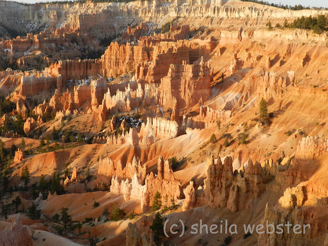
Warm orange colors of the hoodoos
Rows of hoodoos at Sunset Point, Bryce Canyon
There are many amenities in Bryce Canyon National Park that make it easy for visitors to stay awhile.  They have camping, lodging, tours, horseback riding, hiking, interpretive programs, cross country skiing, snowshoeing and a general store for supplies.  All of these are available depending on the season, check their website for availability before your visit.


roots of pine tree are above ground
Tree sits atop the rock in Bryce Canyon

Bryce Canyon sits in the National Forest that was once named the Powell National Forest after John Wesley Powell, the explorer of the American West.  Mr. Powell was the man who led the team that explored the Grand Canyon on the Colorado River.  It was renamed the Dixie National Forest in 1944.
View of hoodoos and trees from Sunset Point
Bryce Amphitheater in Bryce Canyon
The setting sun has little chance of penetrating through one big cloud that sits in the way, but we are getting a little bit of that orange glow that would light up the hoodoos if only that cloud wasn’t there!  The white limestone takes on a brightness that is only there in sunrise and sunset lighting and the limestone oxidized by iron is a deeper orange color.

The sun has set in Bryce Canyon
Early evening view from Sunset Point, Bryce Canyon

We walked over to a viewpoint at Sunset Point that we hadn’t been to before and we saw a whole new beautiful view of the hoodoos in Bryce Canyon.  Even with that big cloud hanging on the horizon behind us, I cannot imagine a more beautiful sight in Bryce Canyon than what we see here.
The sun is down, the air is getting chilly and the sunset-watching crowd is leaving.  It is time to move on to our next adventure. 

Wednesday, May 23, 2012

Sunrise in Bryce Canyon ~ Bryce Canyon National Park ~ Utah

We rose early so we could be sure to see the sunrise in Bryce Canyon, one of the prettiest times to enjoy a sight like this and to take advantage of great lighting, too.  The viewpoints in Bryce Canyon all face east so they are all great places to be but we chose to go to Sunrise Point on this cool April morning.

watching the sun come up over the horizon in Bryce Canyon
Sunrise Point in Bryce Canyon National Park

We were there early enough to see the sun cresting the mountains in the distance.  On a clear day you might see over 180 km (100 miles) from some viewpoints in Bryce Canyon but my only concern on this visit was how the incredible sight in front of us looks while the sun rises. 
the view from Sunrise Point in Bryce Canyon
The sun shines on white limestone in Bryce Canyon
 As the sun slowly begins to shine on the hoodoos in the distance, the pure white limestone looks luminous as though it is made of china. Limestone changes color due to the minerals that cause oxidation, but these white hoodoos look beautiful in the early sun.
a close-up of white hoodoos in the distance
White hoodoos in Bryce Canyon
This close-up of the hoodoos shows the details of what resembles the ruins of an old city on the hillside in the distance. A little imagination and you might see wonderful structures in the amphitheaters, many of them have been named according to legends or history.   
The sunrise casts a warm glow on the hoodoos
Bright colors of oxidized hoodoos in Bryce Canyon
The sun is rising quickly now and the shadows and colors are changing so I move on to get as many photos of as I can.  The predominant orange colors are a result of iron oxidizing and gives an incredible bright orange to the hoodoos during the sunrise.  
The sun adds brightness to the orange hoodoos
Hoodoos among the trees in Bryce Canyon
As the sunshine hits these hoodoos, they light up and stand out among the trees.  The elevation at Sunrise Point is 2443 meters (8015’) and patches of snow can still be seen.  We had great weather conditions for our visit but those who arrived one week later were dealing with colder temperatures and fresh snow. 
visitors are having a close up to with the hoodoos
Standing among the Bryce Canyon hoodoos
Many visitors had walked along the path below to get a closer look at the hoodoos as the sun rose.  We were here with many others and their cameras also waiting for the sun to give us her glorious glow on the hoodoos.  We are on the rim of the plateau on the eastern edge of Paunsaugunt Plateau.  This Paiute name means ‘home of the beaver’ 
hoodoos appear to be lit up in the sunrise sunshine
Ever changing colors in the Bryce Canyon sunrise
The Bryce Canyon was named after Ebenezer Bryce, who brought his family here in 1875 to live and harvest the plateau timber.  The locals began calling it Bryce Canyon and the name became official when it first became a National Monument in 1923, the name remained when it was designated a National Park in 1928. 
looking into the amphitheater at Sunrise Point in Bryce Canyon
Hoodoos standing tall amid the trees in Bryce Canyon
We did not allow time to enjoy some of the 80 km.(50 miles) of trails that are throughout the Bryce Canyon National Park but if conditions are suitable, I would recommend making time for that.  There are 8 different day hikes ranging from easy to strenuous, many are interconnected and guidebooks are available for trail information. 
The rising sun casts shadows among the hoodoos.
Shadows and highlights from Sunrise Point in Bryce Canyon
These hoodoos looked magnificent in the morning sun.  The Paiute history says the animal legend people were bad so the Coyote turned them all into rocks and the Paiute translation for Bryce Canyon is “bowl shaped canyon filled with red rocks standing up like men”.

There are over 1.5 million people visiting the park every year and I feel fortunate that we were among those in 2012, what an amazing sight to see.  Visit more of our Bryce Canyon sights when you click here. 

Tuesday, May 22, 2012

Bryce Canyon National Park ~ Bryce Canyon ~ Utah

We had  a beautiful drive through Red Canyon in the Dixie National Forest following Scenic Byway 12 onto Hwy 63 for the short distance to Bryce Canyon City.  We set up our RV's in Ruby's RV Campground, (there are campgrounds within the park, but availability depends on the time of year) which is a great place to stay when visiting Bryce Canyon National Park then we soon headed out to visit the much anticipated Bryce Canyon.

a view of the trees and hoodoos from Sunrise Point
Sunrise Point in Bryce Canyon
We arrived early afternoon on a beautiful sunny day and our first stop after entering the Bryce Canyon National Park was at Sunrise Point, elevation 2,438 meters ( 8000').  The high elevations make for clean crisp air and a view that goes on for miles.  A cost of $25.00 per vehicle allows 7 days to visit the National park.
The horses and mules take the riders down the trail
Horseback riding into Bryce Canyon
There were many visitors enjoying their adventure in Bryce Canyon on mules or horseback.   The 90 minute rides are led by guides therefore beginners are welcome to enjoy the experience, too.  This would be a great way to get down from the rim's edge and see those hoodoos from a different view.
Afternoon sun shines down to highlight the hoodoos
Beautiful hoodoos from Sunrise Point in Bryce Canyon
Bryce Canyon National Park is open year round but there are over 200 days of freezing temperatures so one might want to choose according to your interests.  There are many hiking trails to follow in here during fair weather, like we had but there is also cross country skiing when there is enough snow and I understand the views are always spectacular.
tree roots above ground in Bryce Canyon
Hoodoos amid the trees in Bryce Canyon
The exposed roots of the trees in the canyon tell that the cliffs are retreating about one foot every 60 years.  This tree just appeared to be standing atop the sand but looked healthy in spite of not having the roots buried. The Bristlecone pine best survives the most severe of temperatures and can be seen throughout Bryce Canyon. It is the oldest living single organism and the oldest Bristlecone pine tree is almost 5000 years old.
The grotto shows along the wall of the canyon
Grotto at Bryce Point in Bryce Canyon
The erosion that occurs over the centuries caused cave-like forms that are called a grotto. These all appear in a row across the valley and the Wall of Windows, which began as grottos, stands behind. The caprock preserves the tops of the pinnacles for a while but they will eventually crumble, too.
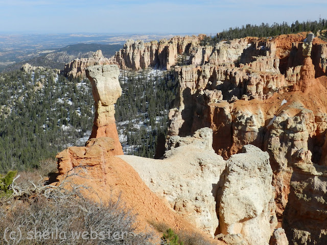
A single hoodoo stands close to the rim
Agua Point in Bryce Canyon
Agua Point is one of thirteen viewpoints on the route of just over 60 km (38 mi) as you travel the round trip in Bryce Canyon.  It is the smallest National Park at 145 sq. km (56 sq. miles) but every viewpoint offers an incredible view. The Bryce Canyon with its' fascinating geology is part of the Grand Staircase region.
a great example of a natural bridge due to erosion
Natural Bridge in Bryce Canyon
This Natural Bridge is at an elevation of 2630 meters (8627') and is a result of erosion over the years, even though it looks like it was man-made.  It is just another example of how nature can create some incredible sights.   
This part of the country has so many amazing sights to see that it is difficult to choose what to share next but Bryce Canyon is one of the most spectacular!  We were able to spend time there for both a sunrise and a sunset and I will share those photos, as well.

Friday, May 11, 2012

Zion Canyon ~ Zion National Park ~ Utah

Our crisp spring morning with sunshine and clear blue sky looked perfect for a day of sightseeing in Zion Canyon within Zion National Park, (see where we spent our previous afternoon).  Zion Canyon is only accessible by the shuttle bus service, which they offer as part of the park entrance fee, from April to November so we headed out to the Park early to get a parking spot and to spend our day seeing the sights. 


The sun shines on three peaks in the canyon.
Early morning sunshine in Zion Canyon

The name Zion was first used by Mormon settlers from Salt Lake City in the 1860’s who came to grow cotton in the warm climates and the name implies peaceful or heavenly and means “promised land”.  Many of the names given by the Paiutes and early settlers had religious origins, for example the Great White Throne, the Organ and Angel’s Landing. 
The sunny day shows the river lined with green budding trees
The Virgin River in Zion Canyon, Utah
There were Ancestral Puebloans dating back to 7000 BC inhabiting this area but it would not have looked like this then.  The Virgin River cuts down through the sandstone rather than the normal sideways pattern of rivers and the wind and rain are always changing the massive stone formations. 
Down at river level looking toward the narrow passageway in the river.
The Virgin River meanders between narrow canyon walls
We rode the shuttle to the last stop and then walked a path to the end which brought us to a part of the river where the canyons are only 20 ft. apart. Hikers were wading through the river and following the canyon further up the Virgin River to see sights that we would never see but for the appropriately dressed and more ambitious hikers, there is much to see and enjoy past this point, so I am told. 
Photo of running wild turkey.
Wild Turkey runs down the roadside in Zion Canyon, Utah
 We would disembark the shuttle at each stop and sightsee until we were finished there then get onboard another shuttle to move onto the next location. The whole route is about 12 km (8mi) long with several stops with shuttles arriving every few minutes.  The wild turkey was running down the road alongside us on one of our shuttle rides. 
The multi colored wall of the canyon where water has carved out parts of it.
Water falls down Zion Canyon walls
 There is lots to see and you should allow a full day and that does not include any long hikes.  We covered lots of walks and most of them are paved and accessible for the handicapped but there were many hikes that we did not even attempt. The high elevations  might make breathing difficult for some people, I was not over a chest cold and had to take several rest stops to catch my breath and we were not following strenuous paths.
Squirrel keeps his eye on me while I take photos.
Squirrel in Zion Canyon
We did see a few deer on our walk through the Canyon.  They were not far from us but seemed fairly familiar with their visitors to the Park and continued eating as we passed by.  This little squirrel seemed to follow us along the path and stopped for photos more than once.  Did you know that squirrels dug holes in the dirt to do their business like cats do?  unless he was just trying to impress us with the message  ‘keeping my park clean’!    
The mountain Angel's Landing stands tall beside the Virgin River.
Angel's Landing in Zion Canyon
 One of the most famous sights in Zion Canyon would likely be Angel’s Landing.  It is a strenuous climb for those that have no fear of heights and with proper shoes and gear.  There have been six deaths since 2004 so caution must be taken.  The ridge is narrow and it is 1400’ above the canyon floor.
The hikers can be seen on the pathways in the distance.
Hikers walking up to Scout Lookout in Zion Canyon
There were many people enjoying the Zion Canyon on this sunny day and many of them were climbing to Scout Lookout at the base of the Angels’ Landing but fewer were continuing on from there.  If you look closely you will see these people zigzagging up the hillside where the path has been carved. 
The trail follows the curve of the canyon wall where the water falls.
Lower Emerald Pools Trail of Zion National Park
We followed a very busy Lower Emerald Pool Trail that wanders along the Virgin RiverThe water level at the lower Emerald Pool was low so we saw very little water but there was some falling over this bank causing a spray on the path, it would have been a great sight to see at the height of spring runoff.  There are three sets of Emerald Pools with the distance to each given on a legend at the beginning of the pathway.
The river flowing down the canyon in the shade.
Some of the Zion Canyon sees little sun during the early morning
Zion Canyon has so much to see and do. The Zion Lodge is there for those who wish to stay awhile.  It has a restaurant and a place to pick up great snacks for a picnic to take to one of the many picnic areas. There are over 200 miles of all levels of hiking trails which are marked accordingly, bicycles for rent and horses offer trail rides as another way of enjoying this beautiful canyon.  We did see some rock climbers enjoying their sport, as well. There is something here for everyone. 

Thursday, May 10, 2012

Zion National Park ~ Utah


We love rv’ing and we are snowbirds which means we are so fortunate and we can do as many other Canadians do and go south for the winter.  Making our way home in the spring then gives us the opportunity to travel different routes and have adventures that we haven’t had before.  Last year we visited the Grand Canyon on our way home and it was spectacular so this year we have our sights set on other places in Utah.

A cabin on the hillside in Zion National Park
Zion National Park in Utah

Zion National Park in the southwest corner of Utah is one of the incredible sights you will find in the Grand Circle, known to have several spectacular canyons.  We travelled with friends and for our Zion visit we parked the RV's in Hurricane, Utah and followed Hwy 9, the Zion-Mount Carmel Highway for a beautiful scenic drive that took us through the Park.
the reddy brown road meanders through the sandstone mountains
 Zion - Mount Carmel Hwy in Zion National Park
Zion National Park was designated by Congress in 1919 and is the oldest and most visited National Park in Utah.  The entrance fee is $25.00 per vehicle for 7 days and as many visits in that time as you wish.  There are two campgrounds in the park with varied amenities, check out their webpage for details if you’re going to stay in the park. 
There is an opening in the side of the mountain which is part of the tunnel
The window of the Tunnel in Zion National Park
 A tunnel was built during the1920’s to gain access through to Bryce and Grand Canyons and that was completed in 1930.  This photo shows one of four windows in the tunnel which is how construction began.  These openings were a source for air and light and work was done from the middle to each end.  The crews worked 30-36’ per day.
the road takes us into the tunnel
Opening to the Zion tunnel
 The tunnel is 1.8 km (1.1 mi) long and does not have the room for the big RV’s of today and semi-trucks to pass through it.  They will allow big pick-up trucks to pass through but there is a $15.00 additional cost for this as they stop oncoming traffic so that allows you to travel down the center of the tunnel. This extra fee pays for two times to pass through the tunnel and we did!
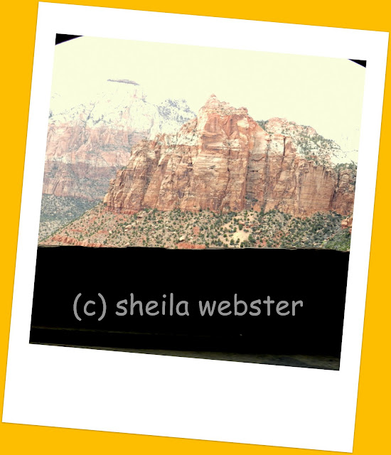
the view you would see if looking through the tunnel window
View through the tunnel window 
There were only our headlights to see with so as you can imagine, it is pretty dark travelling through the winding tunnel. With no places to stop or pullover, the photos I took through the windows as we passed weren’t great but this one shows the quick view we had. 
rock formations on a tree covered hillside
Formations in the rocks
 There was nowhere to look that there wasn’t something fascinating to look at, I see the profile of a yawning animal here, but others might just call it a rock.  There are many places to park so you can get out and walk along the many trails and see the sights.
markings on the hillside look like lines drawn across the mountain
Windswept lines in the sandstone
Some of these formations were amazing to see.  The Navajo sandstone show lines that sweep across in different colors and these show the movements of the sandstone over the thousands and thousands of years.  It is hard to comprehend how this has evolved over all those years but these rocks do tell the story. 
The lines criss cross on the mesa making it look like a checkerboard
Checkerboard Mesa
Checkerboard Mesa is 2033 metres (6620’) high and is a great demonstration of the lines of time.  The crossbedding, which are the horizontal lines represent layers of windblown sand and the vertical lines are shallow cracks from erosion and changes in temperatures as the cold contracts and heat expands so stressing the sandstone. 
the bright orange plant grows from the rocks
Indian Paintbrush in bloom
 Our visit was in April so we were lucky to get great weather in these high elevations.  It was still early for spring growth but we did see signs of new growth happening.  The Indian Paintbrush plant, which we also see at home, was growing out of rocks along the road and soaking up the sun that did appear part way through our day.

A young sheep stands on the rocky bank watching the cars go by
Desert Bighorn Sheep

The Desert Bighorn Sheep can often be seen on the east side of the Park, and this young one was quite curious about the traffic passing by.  Mountain lions are also known to inhabit the Park but rarely seen and there has never been an attack by one.

We saw some beautiful scenery through the Zion National Park; the sandstone rocks were so many different colors, the Ponderosa pine and mesquite dot the hills and we left the Park looking forward to seeing the Zion Canyon on our next day of this adventure.  Can it get any more beautiful and fascinating than it already is? 

LinkWithin

Related Posts with Thumbnails