Showing posts with label CA. Show all posts

Saturday, June 28, 2014

California sunset ~ Marina, CA

Our travels up the California coastline have us driving through sunshine, cloudy skies and even some rain.  I would much prefer we not deal with rain, but as long as it does not interfere with our sightseeing, we’ll manage.  I’ve sent word out to the weatherman!

Marina Dunes Rv park at Marina, CA
We are booking the RV parks as we travel and usually stay in unfamiliar places to explore where we haven’t done before.  This will be our first visit to Marina, just north of Monterey, CA. where we had stayed on a previous visit to the coast.  We booked into the Marina Dunes RV Park and did find it expensive for just an overnight stop when not taking advantage of their amenities. RV parks near the water are pretty rare but we wanted to be within walking distance of the ocean.

Marina State Park, CA
The location was great for our stay.  We had easy access to Marina State Beach, with the entrance right across the street and a fenced pathway to follow.  The clouds had gathered and were not allowing the sun to shine down on us but we headed over to watch the sunset.

Seascape beyond the dunes
The dunes are a great sight, with blooming flowers that add color to the growing darkness.  The sun is still trying to shine down but struggles to fit between those dark clouds.

Are we there yet?
The wind was pretty strong and the chill in the April air warranted jackets for our walk but we trudged up the sandy walk to get ourselves to the beach.  We followed our friends up the heavily travelled path but we saw few others out on this cool and windy night.

Enjoying the view
More clouds are gathering and not offering much chance of a cloudless sunset, but there is always hope.  The wind blows and the waves crash; it is wonderful to see, feel and hear the ocean. We are enjoying the view.

Clouds cover the sun
I am determined to see the sun set and look forward to watching it from the beach so we wait awhile longer.  Will the dark bank of clouds move away in time to watch the sun slide down behind the horizon? 

April sunset at Marina, CA
Alas, it did not.  I’d hoped to see what I thought to be a “perfect” sunset but the weatherman missed the memo.  But… the sunset was beautiful anyway, with sunrays beaming through the clouds.  How could I think otherwise; we were enjoying our travels and adventures and now we were watching a sunset on the beach with great friends. Perfect!

Tuesday, February 18, 2014

President's Day ~ Air Force One ~ Palm Springs, CA

President’s Day 2014 in the U.S.A. was celebrated on Feb. 17.  It was first created for George Washington in 1879, called Washington Day and always on his birthday.  It has changed over time and now honors the office of the Presidency on the third Monday of February.  President Barack Obama was visiting Palm Springs, California on this President’s Day of 2014.  

Kirk Douglas Way entrance sign 
The Coachella Valley, home of Palm Springs had been buzzing with the news that the President was coming for a visit.  President Obama met with the King of Jordon for official business then some golfing fun with his highschool friends over the President’s Day week-end.

Air Force One sits at Palm Springs Airport
We made our way to the airport hoping to get to see Air Force One and were amazed to be able to get up so close.  I expected it to be out of sight for security reasons but that shows my lack of knowledge in that department.  It was very close to a public area so photos were easy.  Several other people had the same idea as we did and they were all busy with their cameras.

Boeing 747-200B aircraft
The airplane is over 231 feet long so it isn’t easily hidden but I sure was happy to be able to see it without buildings in the way.  My biggest challenge was to get a palm tree in the photo and to keep walking until I found that right location.  It isn’t Palm Springs without a palm tree in the photo!

In Remembrance monument at Palm Springs airport
Palm Springs does not have a very large airport but it is very secure.  This monument was dedicated in 2003 as following 9/11 Palm Springs was the first in the nation to develop a centralized vehicle inspection plaza. There is no doubt that security has been even more with this weekend visit by the President.

Visit by Air Force One at Palm Springs airport
The first to benefit from a presidential airplane was President Franklin D. Roosevelt when the Secret Service configured one that was used in February 1945.  Previous to that there were commercial flights used until security became a concern.

Front view of Air Force One
The name ‘Air Force One’ became used after a 1953 incident making a name change necessary but it wasn’t until 1962 that it became official.  There were a few names used before this one such as ‘Guess Where ll’, ‘Sacred Cow’ and ‘Independence’ with a bald headed eagle painted on the plane but Air Force One definitely sounds best and gets my vote.

The seal of the President of the United States of America
There have been several aircraft used over the years but presently there are two Boeing VC-25A’s that are highly customized for use by the President.  The aircraft is called Air Force 2 when used by the vice-president.
Air Force One sits near the Palm Springs airport terminal
Air Force One is almost a mobile White House for the President when he is away from there.  It has state-of-the-art navigation, electronic and communications equipment, conference room, offices, dining rooms and private quarters for the President and First Lady.

Entrance to Palm Springs Airport
This week-end has now come to an end and activity at the airport has returned to its’ regular busy routine.  The weather was weekend perfect and life here has returned to normal.  The President has left the Valley.

Wednesday, January 9, 2013

Winter Driving ~ Washington ~ Oregon ~ USA

Our winter travels south continue on day two and we don’t have the snow we had on day one, nor do we have the sunshine.  We made it through the Aldergrove border crossing after a 15 minute wait shortly after 8am.  They moved traffic through fairly quickly and we were on our way to meet friends in Lynden, WA who would then travel with us, pulling their trailer down I-5, too.

Heavy fog and slow traffic on I-5 at Everett, WA
I-5 freeway Everett, WA

A lot more traffic on the roads in Washington and the fog certainly is thick this morning but most are driving according to the weather and the roads are not winter roads. There is a lot of freeway driving on this part of the trip south but most of our time is not done during rush hour as we usually try to time the trip so we can avoid that.
Trees silloettes reflected on the lake
Roadside lake near Kelso, WA
This day was fairly uneventful and with the fog following us most of the day, the scenery was almost non-existent so it wasn’t a big photo day but there were some scenes that looked pretty enough for a photo.  This was taken looking into the sun that was just behind these clouds as we neared Portland, Ore.,  making it look like a black and white photo.
A patch of fog sits in a valley in the distance
Fog south of Cottage Grove, Ore
We spent that night in Cottage Grove, Oregon at the RV park adjacent to the Village Green Motel after a good long drive and enjoyed a great dinner in their restaurant.  They are just a short distance off I-5 so make it easy to get back on in the morning to begin day 3. 
Lots of fog but the roads are good for travelling.
Good winter roads at Cottage Grove, Ore

I love the scenery south of Cottage Grove and am disappointed we won’t be able to see more but the fog offers some very neat sights so the camera is busy anyway.  The roads are damp but the temperature isn’t freezing so they are good travelling roads today. 
Visibility is limited but the fog on the hills is great.
Fog on the hills of Oregon

Our destination is Red Bluff, CA tonight so we have a lot of miles to cover that include some mountain passes. We have left early so that we can arrive before dark, which arrives early during these winter months.

A man is walking his bike up this hill
Lone cyclist on I-5 in Oregon winter
We want to reach our final destination on the fifth day of travel but allow for more time in case road conditions dictate that. We’ve never been held up due to snowy conditions but some of our friends have had to deal with that.  One just never knows what lies ahead at this time of the year so be prepared to stay awhile.  This lone bicycle rider is one brave soul to be riding, or walking this part of the country at this time of year!
We cannot see very far offside the road, though.
Good visibility in spite of the fog 
Grant’s Pass is just west of Medford, Oregon and is one that concerns all winter drivers as it does get winter conditions and has been known to require chains in order to travel through these mountains.  Other than the fog and the threat of snow, we’ve not had any weather problems yet.
A nice winter picture, fine snow covers the trees and ground.
Snow covers the roadside hills and trees
The Siskiyou Range of mountains travel along the southern Oregon and northern California border and we don’t usually see snow on our trip south but this year is totally different.  We are seeing fresh snow on the trees that border the highway and we’re driving through clouds and we expect more snow.  We are climbing higher.
Sign shows the elevation and the winter roads
Highest point on highway  I-5
The climb has taken us to the highest point on I-5, which is in the Siskiyou Mountains.  1314 Metres (4,310’) is a big climb and although the outside lane isn’t a real one, the shoulder of this road is wide enough for the big trucks to travel and they do so as to not hold up the other traffic.  There usually is a sign to say if this is allowed.  Consideration in this matter is always appreciated by other motorists.
The snow and fog are not the usual sight we see here.
Welcome to California ~ foggy and snow
We’ve made it over the highest elevation and the snow hasn’t stopped but at least we were through the worst of it without having to put chains on our tires.  We did learn later that these passes had been closed a few times during the previous week, so we did time it nicely.  
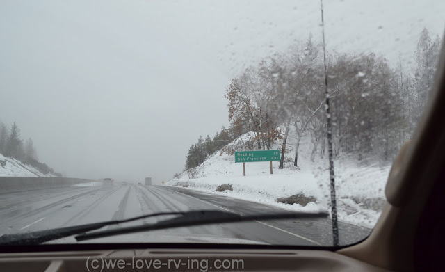
Very cold and snowy rest stop
Rest Area north of Weed, CA
The thermometer in the truck for the outside temperature reads -2C (29F) so it is cold out there.  We call our friends on the two way radios we carry for these travels and make a stop in a Rest Area.  We take a break, make some lunch and walk the dogs.  These Rest Areas make it easy to get out and stretch, always a good idea every couple of hours and they offer clean restrooms, too.
these prove we're going in the right direction!
California mileage signs on I-5
We’re back on the road in no time and happy to have the mountain passes behind us.  The fog is still pretty thick but we know we only have a couple more hours to go before we stop for the night in Red Bluff, CA. 
The foggy Lake Shasta is barely visible
Lake Shasta, CA
Lake Shasta is shrouded in clouds but we’re able to see the marina, not much activity there today. We carried onto Red Bluff, CA and stayed in Durango RV park, also easy access from the freeway and enjoyed a beautiful RV park with nice amenities and nearby restaurants and shopping.


We’re not there yet so stay with us and we’ll share some more winter travels.

LinkWithin

Related Posts with Thumbnails